
A cold front will continue to move into the area through the next 24 hours, ushering in cooler air. Ahead of the front, we hit 80 degrees in Lafayette this afternoon, but the cooler air has begun to make its move. Overnight lows will be in the upper 40s/lower 50s, so a chilly start to your work week. Highs climbing into the mid-60s tomorrow under mostly sunny skies. Coolest air arrives Tuesday and Wednesday with highs in the mid-upper 50s and lows in the 30s both Wednesday and Thursday morning.
Nice weather is expected through Thursday, but by Friday and Saturday, that will be changing. A cold front is expected to work into the south-central U.S. on Thursday. Meanwhile, increasing upper-level energy will allow a surface low to form along the front in south-central Texas. Models show this low pressure moving into eastern Texas Friday night and tracking across Louisiana Saturday morning/afternoon. Both major models, the GFS and European, show very heavy rainfall associated with this low pressure system. Depending on how far north the warm, unstable air gets, we could see a severe weather threat with this system as well. Unfortunately, models agree with this storm coming in Saturday, which would be election day across the area. I do have to stress, however, that it’s still 5 days out, so the finer details could and mostly likely will change. As of now though, both the GFS and European show the possibility of 2-4 inches of rain in a narrow strip right along the low pressure, where lift will be enhanced. Some isolated higher amounts could be possible.
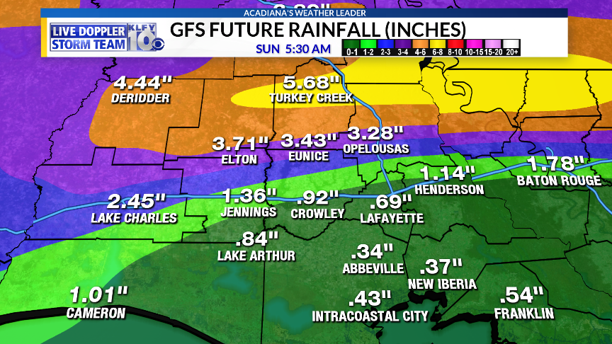
GFS Model: Rainfall Accumulation through next Sunday.
We’ll continue to track this system through the week ahead.
~Meteorologist Trevor Sonnier
