Tropical Storm Gamma is now moving north into the Gulf of Mexico this morning. The storm should encounter higher wind shear through the next 24 hours, which could lead to a weakening trend. High pressure will also build to its north, causing the storm to turn west and then southwest through the next five days. This would push it into the Bay of Campeche and not allow any northern movement.
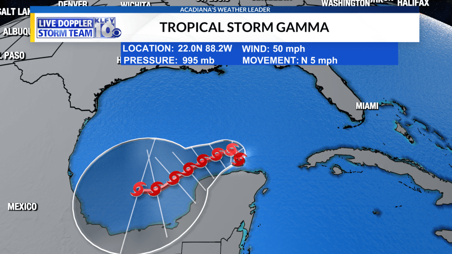
It’s unlikely Gamma will pose a threat to the northern Gulf coast as it appears high pressure will protect the area.
There’s another disturbance in the Caribbean, however, which needs to be monitored. The National Hurricane Center is currently giving this system a high chance for development within the next five days.
The system will move northwestward and be somewhere in the south-central/southeastern Gulf by the middle parts of this week. There could be a brief window of development and/or intensification once it’s in the southern Gulf, as high pressure aloft will lead to a favorable upper-level environment. It does appear, however, these favorable upper-level conditions may not last long. By the weekend, an upper-level trough will move eastward across the Gulf, imparting southwesterly shear on the system. This could weaken whatever becomes of this system down the road. In terms of track, it appears the system could stall across the central Gulf mid-week with possibly a slow westward movement Thursday and Friday. Thereafter, a trough will eventually turn the system back northeast. Specifics are murky and it’s still too early to have a confident forecast on this system. It could swing some moisture our way through Thursday, Friday, and Saturday–increasing our rain chances.


