
Hurricane Hanna has gotten its act together in a hurry. It was a tropical storm yesterday, but overnight the storm strengthened and its structure vastly improved. It developed an eye-like feature overnight, cleared out the eye this morning, and now is packing winds of 90 mph. Doppler radar, microwave data, and Hurricane Hunter aircraft all find evidence supporting an intensity of 90 mph, just shy of Category 2 status. The storm will continue to move inland over south Texas and weaken over the mountainous terrain of Mexico.
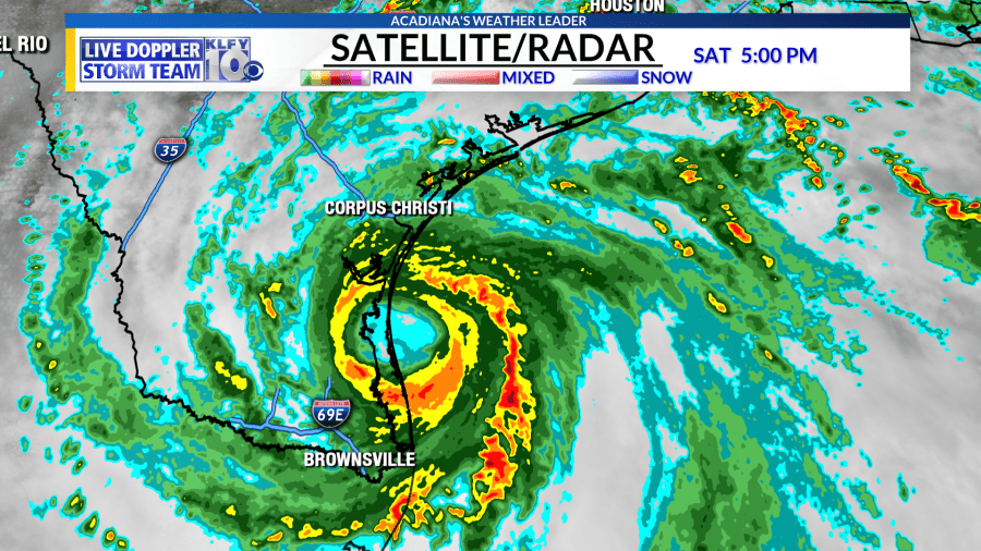
In the meantime, hurricane conditions are expected for a good swath of the south-central Texas coast. Storm surge of 2-4 feet will be common just north of the landfall location. Water levels of 4-6 feet above ground could be possible during high tide. Life-threatening rains also anticipated across much of south Texas and northeastern Mexico.
GONZALO….Good news in regards to this system is that this system is no longer a tropical cyclone. After being downgraded to a depression earlier this morning, the system finally dissipate due to hostile atmospheric conditions. Regeneration is not expected at this time.
Long-range models are showing development from a strong tropical wave, currently located across the central Atlantic. This wave has a high chance of development within the next five days as it works westward towards the Lesser Antilles islands and the Caribbean. Both the long-range GFS and European model now develop this system into a tropical cyclone in about 4-8 days. It’s way too early to know where this potential system will track, but several models keep it far enough south to possibly impact land areas down the road.

With the African wave train in full swing, busy times are sure to be ahead in the tropics. The peak of the season occurs in early September.


