
This stagnant pattern that has produced multiple rounds of heavy rainfall and severe weather through the past few days looks to continue through today, Friday, and Saturday.
Looking at things this afternoon, a narrow band of very heavy rainfall has developed across the northern tier of Acadiana, spawning numerous Flash Flood warnings. Some areas have already received 2-6 inches of rainfall with additonal rainfall of 2-5 inches likely thorugh this evening. This is due to this slow-moving storm complex which will continue to sag southward ever so slowly through this afternoon and evening. Models have this activity weakening through this evening as it moves towards I-10, keeping the highest rainfall totals, for now, north of I-10. I do have to stress that high-resolution models may struggle with this activity and its evolution due to the fact storm motion is caused by these small outflow boundaries and not by a large-scale cold front. For this reason, even parishes along and south of I-10 will have to watch for the possibility of the flood/severe threat shifting southward through the afternoon and evening. Storm motion in the atmosphere is southwest to northeast while momentum is from north-to-south. This will cause storms that will both develop and move erraticly. With atmsopheric moisture exceeding 200% of average, these storms will be capable of dumping heavy rainfall, on the order of 2-3 inches per hour, very quickly. So for now, flooding is imminent across northern Acadiana this afternoon, becoming possible for areas further south later today and tonight. High-resolution models show a narrow band of 5-8 inches through tomorrow morning, mainly north of I-10.
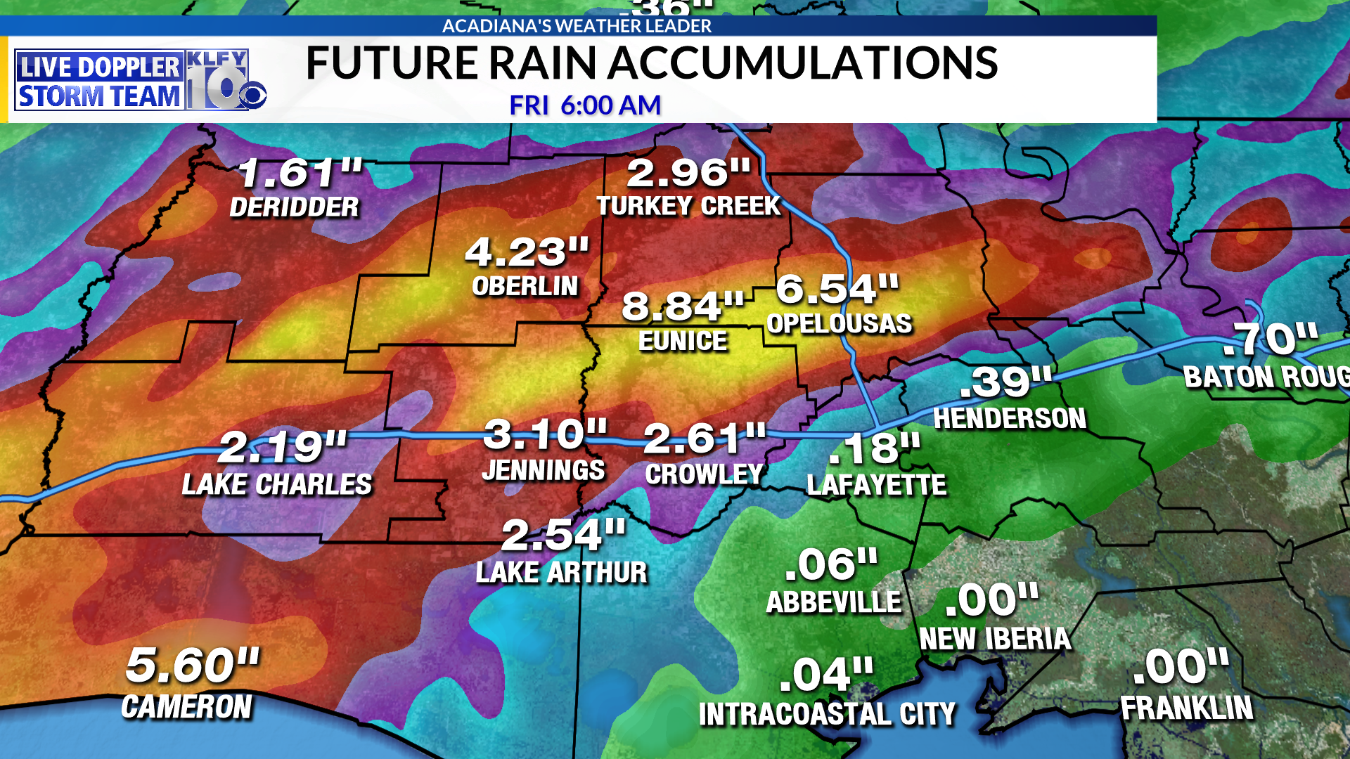
Image 1: HRRR model Rainfall Totals (through Friday morning)

Image 2: Futuretrack Future Radar (Friday morning)
Now for tomorrow, yet another impulse will work into the area through the very early hours of the morning (3-6am). This complex looks quite nasty on high-resolution models, definitely showing a strong wind structure. This is not surprising, taking into account atmopsheric indices for tomorrow. DCAPE (an index I like to look at to help me determine the damaging wind possibility) is approaching 1000 units, which is on the high side. For this reason, I believe Acadiana will have to be on the lookout for storms that could produce damaging winds of 60-70 mph early tomorrow morning. Of course this will also add additional heavy rainfall to already soaked land, so the flooding threat is sure to continue through tomorrow, possibly for areas further south than where it is today.
REMEMBER….do not drive through high water or flooded roads and keep it tuned to KLFY for the latest information through the storm!
~Meteorologist Trevor Sonnier
