
A cold morning across the area as temperatures have reached the freezing mark in most locations. High pressure will be anchored across the area through today and tomorrow, leading to mostly sunny skies and highs getting into the middle 50s, which is still below average for this time of year. With clear skies and light winds, good radiational cooling setting up again tonight, causing temperatures to be near the freezing mark again tomorrow morning.
South winds will return as high pressure moves east by the weekend, leading to a nice warmup across the area. Temperatures Saturday, Sunday, and Monday will be in the 60s with increasing clouds and moisture.
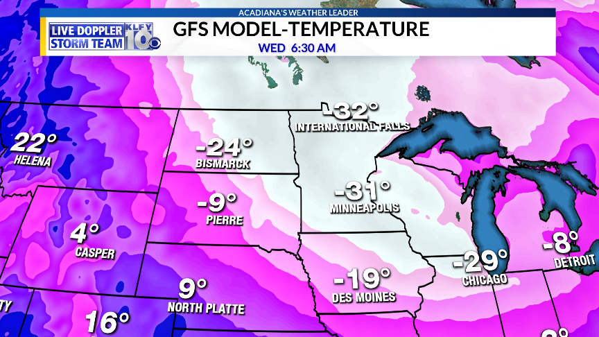
Meanwhile, a frigid airmass will begin to work into the upper-plains and the Great Lakes by Tuesday. In fact, heading through Tuesday and Wednesday, air temperatures will be in the -20 to -35 degree range across parts of North Dakota and Minnesota with wind chills possibly as low as -60!!!
This would be dangerous cold if it verifies. Meanwhile, the Arctic front will be moving through Acadiana Tuesday morning, giving us a rain chance and decreasing temperatures exponentially Tuesday afternoon and evening. We could be in the mid-50s Tuesday morning and drop into the mid-upper 30s by Tuesday evening. In fact, it could get interesting for the central parts of the state and across the Baton Rouge area as the precipitation slowly ends Tuesday evening. Temperatures will hover just above freezing, but the atmospheric air column may be cold enough to produce a temporary window of sleet and/or a few snowflakes right as the rain ends Tuesday evening. The main factor will be how much atmospheric lift remains behind the Arctic front to produce precipitation. It’s a very low chance, but not zero! Chances look a little more remote for Acadiana as most of the moisture should exit the region before the coldest temperatures arrive Tuesday night.

Temperatures will be plummeting into the upper 20s by next Wednesday morning, with highs hard-pressed to reach 50 degrees Wednesday afternoon.
~Meteorologist Trevor Sonnier
