UPDATE: 10:00 p.m. Hurricane Ida has dropped to a Category 2 storm with maximum winds of 110 mph as it closes in on New Orleans, where power has been completely knocked out.
More than 930,000 customers are without electricity across Louisiana, and 28,000 in Mississippi.
UPDATE: 8:00 p.m. Hurricane Ida downgrades to category 3, moving further inland over SE Louisiana
UPDATE: 12 p.m.: Hurricane Ida has made landfall near Port Fourchon with maximum sustained winds of 150 mph.
UPDATE 10 a.m.: Maximum wind speeds have reached 150 mph. Ida remains a Category 4 storm.
UPDATE 4 a.m.: Hurricane Ida is now a Cat. 4 hurricane with maximum sustained winds of 140mph. The track of the storm continues to take it east of Acadiana near the New Orleans area.

UPDATE 2 a.m.: Data from an Air Force Reserve Hurricane Hunter aircraft indicates that #Ida continues to rapidly intensify this morning and is now a Category 4 Hurricane, with maximum sustained winds of 130 mph. Track of Ida takes East of Acadiana near New Orleans.
UPDATE: As of 10 p.m. The eye of Ida is about 160 miles SSE of the Mouth of the Mississippi River.
UPDATE: As of 6 p.m. Hurricane Ida is gaining strength in the Gulf and expected to make landfall as a Category 4 Sunday afternoon.
UPDATE: As of 4 p.m. Hurricane Ida was about 240 miles south-southeast of the mouth of the Mississippi River.
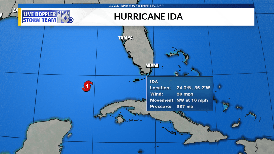
(KLFY) –Hurricane Ida is a category two hurricane with winds of 100 mph, but this will likely be changing soon.
The storm moved over Cuba last night, which disrupted the circulation a bit. However, reorganization is now occurring and a strengthening hurricane is to be expected throughout the day.
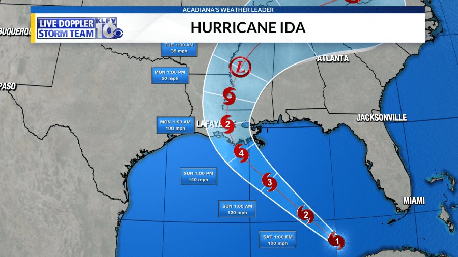
Ida is continuing to move to the northwest and with its heading and forward speed is expected to make landfall tomorrow afternoon or evening across St. Mary or Terrebonne parish, most likely as a category three or four hurricane.
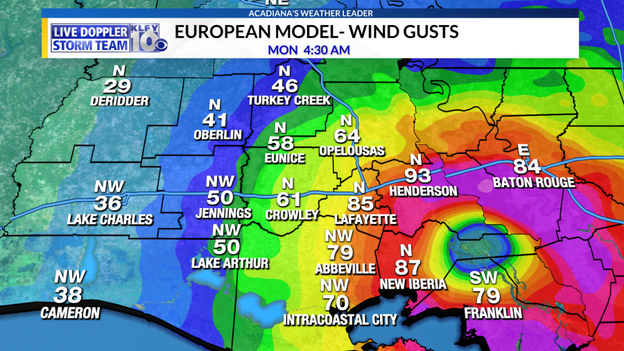
Although heavy rainfall is always possible in a tropical system. I feel the greatest impact locally from Ida will be strong winds. Both the GFS and European models, which agree with the National Hurricane Center on both track and intensity, show a good visual picture of the peak wind gusts expected across the area.

My forecast will be based on the latest National Hurricane Center forecast both in terms of track and intensity. My forecast wind impacts will be sorted from most severe impacts to least severe.
ST. MARY/IBERIA/ST. MARTIN- The eastern and southeastern parts of Acadiana will be the areas that will receive the worst effects of this storm. As Ida makes landfall tomorrow afternoon, St. Mary and Iberia parish could see wind gusts of 80-100 mph. These winds will move northward with the eyewall through the evening and could impact St. Martin parish later in the evening.
LAFAYETTE/VERMILION/ACADIA/ST. LANDRY/EVANGELINE- The heart of Acadiana will see wind gusts of 60-80 mph on the western side of the eyewall as it moves northward. Now, this is an estimate and peak wind gusts 5-10 mph more could be possible, especially across the eastern parts of these parishes. This would be on par with what these areas experienced with Hurricane Delta last year.
JEFF DAVIS/CALCASIEU/CAMERON/ALLEN- Unless we see a western wobble or shift in track closer to landfall, these areas will experience less significant effects. Peak wind gusts of 30-50 mph could be possible.
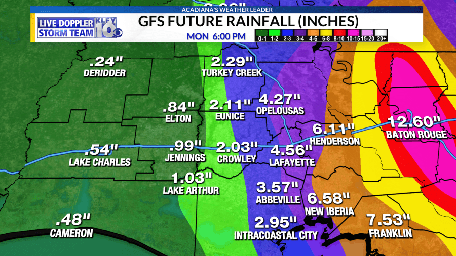
HEAVY RAIN POSSIBILITY- Rainfall totals of 3-6 inches could be possible across Acadiana, but it appears the 10-20 inch rainfall totals, which of course are the most devastating, will be on the eastern side of the storm, mainly across southeastern portions of the state.

STORM SURGE EXPECTED-Storm surge of 3-6 feet is expected west of Intracostal city, while 6-9 feet is expected from Intracoastal City and points east towards Morgan City. The highest surge is expected east of Morgan City where 10-15 feet of surge is expected. These are areas directly east of the eye-wall.


